Hexagon Measurement SystemsNo matter what Hexagon measurement equipment or software you use, we want to hear your ideas and suggestions on how we can improve.
Thanks for your assistance in helping us shape the future. |
|

 Probe Head rotation - collision avoidance into machine bridge legs
When calibrating a longer probe, have PCDmis automatically avoid colliding with the bridge support legs of the frame when indexing for the next angle. Although you can specify the order of calibration, it would be a nice feature to have the machine alarm or automatically avoid this collision in the first place.

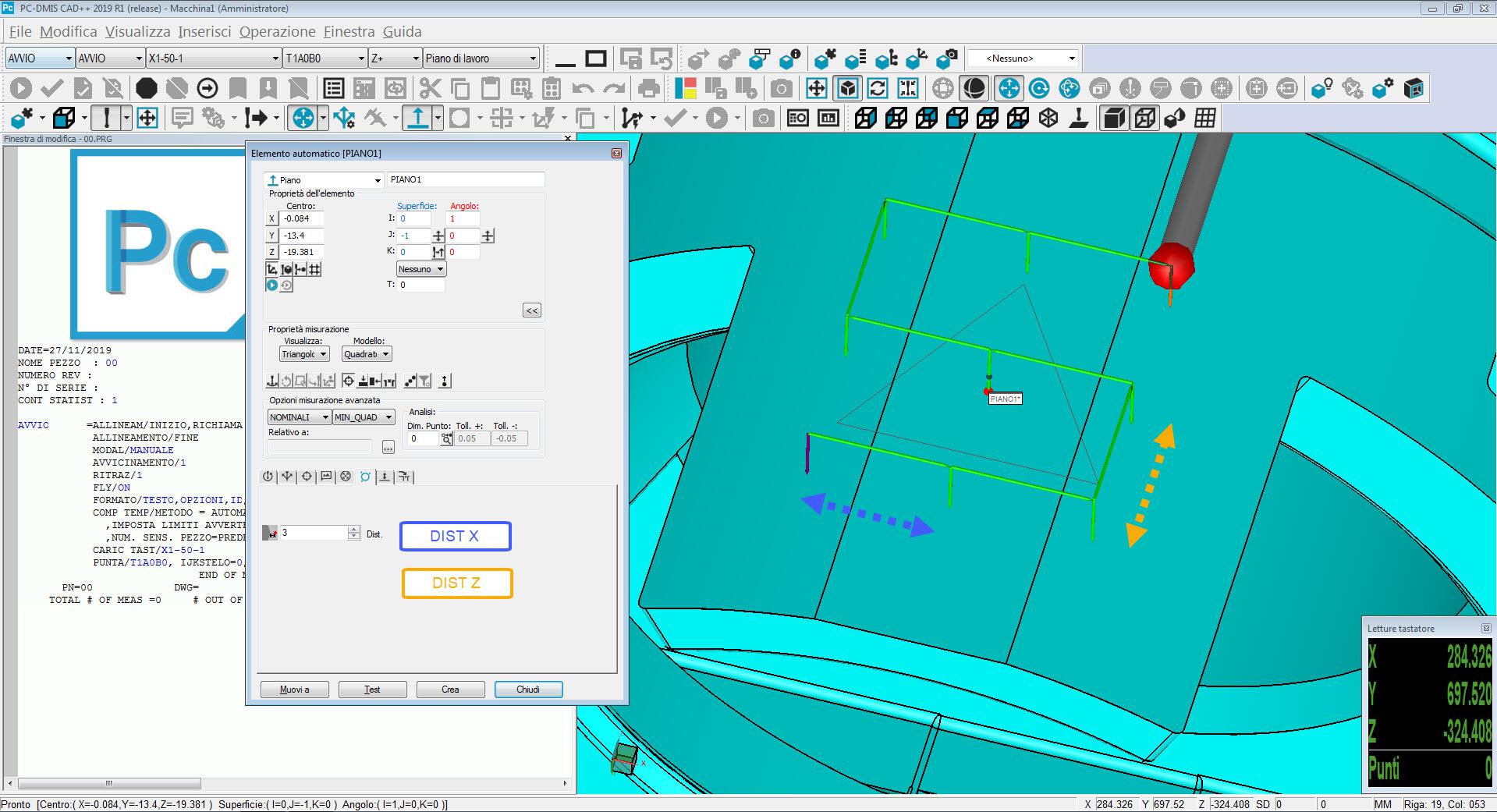
 Add option(s) in Auto Plane feature to allow for better control of hit placement
To add the option to choose different distances for the point in auto plane feature, in order to measure rectangular instead of only square plane, and avoid to change manually the points.

 Changing the measuring system with senmation in pcdmis
We would like to have implied the change of the measuring systems in the Senmation in the PCDMIS. We want to control senmation from PCDMIS. We want to be able to use the functions of Senmation from PCDMIS.
PS: Currently is the changing of the measurment Systems (for instance LSP-X1/ X5 or others ) in senmation only with the so called "Technology Server" possible. This will do the programming complicating.

 Develop of a tool that handles the change of the Adaptive Scanning Strategies Parameters in a set of Auto Feature holes
Actual versions of Pc-Dmis doesn't handles the Copy/Paste Parameters for automatic features with Adaptive Scanning Strategies. If the measurement routines has a high number of features, and you want to change a parameter such as point density, speed, acceleration or filtering options you have to change the holes 1 by 1 with F9 button. If the measurement routine has 5-10 holes it can be done, but if the measurement routine has a high number of holes than this is counterproductive you loose to much time changing parameters.
It is not possible to cancel the features change one of them and after copy it with pattern, because you will loose any connection to constructed features or dimensions.
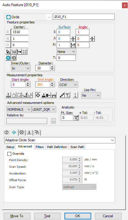
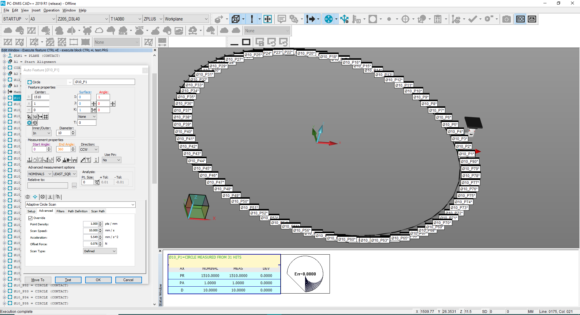
Normal parameters for a Ø10 mm hole are present in the window below, but this means that the measurement will be done with 188 hits. For 80 holes in a measurement routine this is time consuming.
If i want to Override the Point density from 6pts/mm to 1 pts/mm i have to go 80 times F9 and change manually the option for all holes in the same pattern.

 Add Option to Construct a Max/MIn Point From a Scan or Constructed curve
Need to add a construct Max/MIN Point option which can be either be Max Or Min point from an input scan or constructed curve. A lot of customers need to find the highest or lowest point from a scan and the current method of using the MAX or MININDEX to get the scan point number and then constructing a generic or cast point is tiresome. The user should be able to pick a scan or curve, select which axis (based on current alignment) either X or Y or Z and indeed Polar radial for 2D max/min or 3D Max/Min from the current origin.
For example to find the max polar value the user needs to know the syntax below, the software should do this for us.
ASSIGN/POLAR_ARRAY=ABS(SQRT((FINDHEX.HIT[1..FINDHEX.NUMHITS].X^2+FINDHEX.HIT[1..FINDHEX.NUMHITS].Y^2)))
ASSIGN/MAX_PT=MAXINDEX(POLAR_ARRAY)
HEX_CORNER =FEAT/POINT,CARTESIAN,NO
THEO/<0.276,2.287,-4.003>,<-0.0677693,-0.997701,0>
ACTL/<1.914,1.322,-4.004>,<-0.4452459,-0.8954083,0>
CONSTR/POINT,CAST,FINDHEX.HIT[MAX_PT]
This option could also be used for constructing a point from other features such as a plane to then report the XYZ location of the highest/lowest point on the plane or any other feature in fact. etc

 Add an option for hitbased construction of features
Add a checkbox to construction dialogs allowing the user to select whether or not to construct the new feature based on hits (<featurename>.HIT[1..<featurename>.NUMHITS]) or the "regular" way (centroids). This would enhance the programming experience and shave off a couple of minutes to the programming time.

 Align Point cloud select areas.
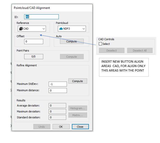
Option to align point cloud and 3D, selecting in the cad only the areas that we need to align. No need to cut those areas that are not interesting.
It would be the same option that exists in the color map, just select the areas that we want to color, but in the alignment of point cloud.

 Constructing New Features from Existing Features
Would it be possible to complete the drop-down list with "Using feature points" or "Recall feature points" or something like that when we want to combine several planes, circles, lines etc (created by scanning or touching points).
I usually use this code, for instance: PLN1.HIT[1..PLN1.NUMHITS],PLN2.HIT[1..PLN2.NUMHITS], but it has to be given by typed with manually.
It would be better if we could select the elements and and choose this "option" (it has been mentioned above) and done.
Thanks in advance for your reply,

 Improve clearance cube functionality
As is, I find clearance cube to be more hassle than it is worth in most situations that I encounter, but with some improvements it could be a valuable tool. I definitely prefer to use clearance planes, avoidance moves, move points, etc. over clearance cube. I understand it was created as a way to automate the programming process but it may be able to improve the manual programming process.
I've outlined some areas where I think this could be improved:
- Make clearance cube smart enough to be able to adjust the status for each feature if a clearance plane is not needed. It is very time consuming to have to go in and click through all the menu items to adjust the active, start, and end status definition for each feature to get an efficient program. This adds quite a bit of time to the process, especially if there are a lot of features to adjust.
- Make it easier and quicker to adjust settings on the fly. Maybe a dock-able window that shows all the clearance cube settings for any specific feature that you can have visible at all times.
- Add clearance cube settings to the auto feature dialogue.
- Make clearance cube settings editable within features in the edit window.
خدمة دعم العملاء من خلال UserEcho
