Hexagon Measurement SystemsNo matter what Hexagon measurement equipment or software you use, we want to hear your ideas and suggestions on how we can improve.
Thanks for your assistance in helping us shape the future. |
|

 Improve changing the datums in GD&T command
When changing a datum of a GD&T command from the command-view the subsequent datums get deleted.
This should get improved. So I can change the middle datum without the last being removed.
Example:
I have the datum system |A|B|C| I want to change it to |A|M|C|
The second I change the |B| to an |M| in the command-view the |C| gets deleted and I only get a |A|M|

 Auto Element Kreis auch mit Teil-Segmente wie an der Optiv (Punkte Auswahl Messbereich) /Auto element circle also with partial segments as at the Optiv (points selection measuring range)
Meine Idee wäre es bei Auto Element Kreis auch mit Teilsegmenten wie an der Optiv zu arbeiten (Punkte Auswahl Messbereich). Somit könnte man Messbereiche einfügen und separat definieren.
Meine Idee wäre, mit Auto Element Circle auch mit Teilsegmenten wie beim Optiv (Punkteauswahl Messbereich) zu arbeiten. So könnte man Messbereiche einfügen und separat definieren.

 adding comments to cmm report
I want the ability to add comments to reports after a run to explain why some dimensions are red on the report, and to type in the dimension we get when measured manually.
I dont want the comments to stay there for the next run. So it doesn't function as a label only as a comment for the specific run.

 CAD Translation Improvement
When translating a CAD model be able to select a feature and tell the software to rotate to a specific direction. Select feature, Rotate to "specific direction" , OK and DONE

 Option to Delete items referenced by commands within the pop up notification
When deleting a feature in the edit window (e.g. an auto surface point), if that data point has a dimension associated with it, a pop up occurs asking "The following commands reference one or more items you are about to delete: xxxyyyzzz Are you sure you want to delete these commands?"
Add an option within that pop up, to delete the referenced commands "Yes or No", with a default answer allowed in the setup. This would eliminate having to go through the routine after deletion and find the dimension, alignment, variable, etc. to delete the referenced command as well as the feature just deleted.
This would also help to mitigate the later opening of routines that give the error upon opening "the following dimensions have no feature id".

 Constructed circle tangent to 2 circles
Hello
Being able to make a constructed circle tangent to 2 circles by imposing the diameter would be useful. For the dimensions on gable pins with rounded teeth for example… This exists with tangent to 2 straight lines so why not 2 circles…
Cordially,

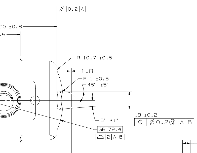
 In construct circle, need an auto cone to pierce an auto sphere and construct a circle where it pierces it
In construct circle, need an auto cone to pierce an auto sphere and construct a circle where it pierces it
Below shows the cone piercing the Sphericle radius to get the Ø18 (the Print is missing the diametrical symbol)
Kundesupport af UserEcho
